The Öland Bridge
6,072 metres across the Kalmarsund, facts, history and practical information on the toll-free Öland Bridge between Kalmar and Färjestaden, gateway to the Sunshine Island.
Contents
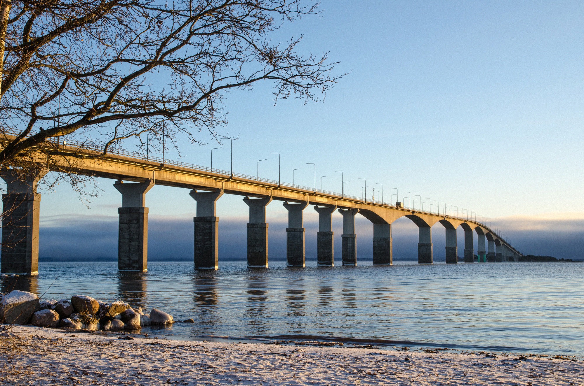
For most visitors, arriving on Öland means crossing the Öland Bridge (Ölandsbron) first. It spans 6,072 metres across the Kalmarsund, the strait between the Swedish mainland and the island, linking Jutnabben in Kalmar with Möllstorp near Färjestaden on Öland. It's the only fixed link between the island and the mainland, and for most travellers, whether arriving by car, by train via Kalmar, or after flying into Kalmar Öland Airport, it's the first and last impression of the island. This guide collects the documented facts and everything practical for the crossing.
The numbers
The Öland Bridge is a bit of a record-breaker, at least by measurement. It's 6,072 metres long (just over six kilometres) and 13 metres wide, resting on 155 reinforced-concrete piers. Clearance over the shipping channel is 36 metres, and its highest point sits around 41.7 metres above the water. It opened on 30 September 1972.
At 90 km/h with clear traffic, crossing the roughly six kilometres takes about 9 to 10 minutes. That's only under normal conditions, though. On busy summer days, with the staggered arrivals on Fridays and departures on Sundays, the crossing can take considerably longer, with waits of 40 minutes or more on record. If your schedule is flexible, cross early or outside weekend peak times.
From record-holder to island lifeline
When it opened in 1972, the Öland Bridge was the longest bridge in Europe, a title it held for 26 years. Only in 1998 did the Vasco da Gama Bridge in Lisbon take it over. So the oft-repeated claim "longest bridge in Europe" was true only from 1972 to 1998, not today.
What still holds is that it's Sweden's longest bridge, measured by the sections lying within Swedish territory. The Öresund Bridge, opened in 2000, is longer overall but only partly on Swedish territory. Before 1972, Öland relied on ferries, the last regular car ferry across the strait, the Kalmarsund VII, ran until the bridge opened on 30 September 1972. With the bridge, the Kalmar-Färjestaden car ferry disappeared, and tourism to the island picked up noticeably. For more on how that shaped the island, see the overview Öland Facts & Figures.
Toll-free, and likely to stay that way
The Öland Bridge belongs to the Swedish Transport Administration Trafikverket and in 2026 is toll-free (avgiftsfri) for every vehicle. No charge applies, whether you're driving a car, a motorhome or towing a caravan.
Introducing a toll does come up now and then in local politics, but it's seen as practically unworkable, the burden on commuters and tourism would be too great. There's no concrete charging plan at present. For your travel budget, that means the bridge remains the cheapest way onto the island. The seasonal car ferry Oskarshamn-Byxelkrok in the north, by contrast, is a paid crossing and more of an experience than a money-saver; full details are in the guide Ferries to Öland.
When the wind picks up, storm closures
The Öland Bridge is exposed, and wind over the open Kalmarsund can blow hard. Trafikverket manages the bridge in stages according to wind speed:
- From 27 m/s (around 97 km/h), wind-sensitive vehicles such as motorhomes, trailers and lorries should avoid the bridge.
- From 32 m/s (hurricane force, around 115 km/h), it's closed to all traffic.
Since 14 May 2018, Trafikverket (rather than the police) has been responsible for closures, with red-light signals and barriers installed for the purpose. When the bridge is closed, traffic turns back at Svinö on the mainland side and at Färjestaden on the island side. The warning is worth taking seriously, trailers have been blown over on the bridge during storms before. If you're travelling with a caravan, trailer or tall motorhome, check the weather forecast and current traffic reports before setting off. Beyond the wind restrictions, there are no official limits on height, width or weight, the weather is the only factor.
Cyclists and pedestrians, the cycle ferry
Neither bikes nor pedestrians are allowed on the bridge itself. That's exactly what the summer alternative across the strait is for, the cycle ferry M/S Dessi, operated by Ressel Rederi on behalf of Kalmarsundstrafiken. In 2026 it runs daily from 15 June to 16 August between Tullhamnen in Kalmar and the harbour at Färjestaden (Södra hamnplan).
- Crossing time, around 30 minutes.
- Capacity, up to 118 passengers and about 50 bikes, with bike transport included in the ticket.
- Indicative adult fares, single crossing around 80 SEK, return around 134 SEK, a 10-trip card around 540 SEK; children under 13 travelling with an adult go free. Pay in advance or on board by card.
The official sources don't give a detailed 2026 timetable, the number of daily crossings is roughly a dozen or so, so check the binding departure list directly with the operator at ressel.se/kalmarsundstrafiken. The fares above are indicative too and should be verified before you travel. If you're exploring Öland by bike, the full picture is in the guide Cycling on Öland; a traditional car ferry Kalmar-Färjestaden hasn't existed since 1972, the Dessi carries only passengers and bikes.
What's waiting just past the bridge
On the mainland side, Kalmar is worth a stop before or after the crossing. The Renaissance castle Kalmar Slott is only about 750 metres from the main railway station and an easy walk; which parts of it require a ticket changes from time to time, so check on arrival. For parking in Kalmar, municipal car parks are free (for a limited time) on Saturdays and Sundays, and chargeable on weekdays from 9:00 to 18:00. The car park on Slottsallén near the castle is free but often full; the one between the town park and the station is chargeable but usually has space.
On the island side, Färjestaden is the first town, about 15 minutes from Kalmar. Right after the bridge on the right is the year-round tourist information office (Ölands Turistbyrå, Träffpunkt Öland), with a nature exhibition run by the county administrative board, a good first stop for maps and tips. For stocking up, there's a Coop Stormarknad right by the bridgehead (Brofästet) and an ICA Kvantum in the Ölands Köpstad shopping centre (open daily roughly 7:00 to 22:00). For more on farm shops and the island's famous loppis flea markets, see the guide Shopping and Loppis on Öland; for an overview of the island's towns and villages, see Places and Villages on Öland.
If you'd like to look back at the bridge from the island side, there's a good vantage point from the third floor of the Borgholm Castle ruin, around 40 kilometres north on road 136, on a clear day the bridge is visible far to the south. Practical information on the ruin is in Borgholm Castle. For the best ways to reach the island overall, see the overview Getting to Öland.