Öland Facts & Figures
Size, climate, windmills, World Heritage status, the royal palace and island cuisine, the documented facts about Sweden's sunniest island, clearly explained.
Contents
A few numbers and facts help put Öland into context, they explain why this flat island in the Kalmar Strait feels so different from mainland Swedish life, and why it gets so busy in summer. Here are the key facts, sourced and without the gloss.
Location and size
Öland lies in the Kalmar Strait off Sweden's south-east coast and is the country's second-largest island after Gotland. It's strikingly long and narrow: well over 130 kilometres from its southern to northern tip, but only a few kilometres wide. The terrain is flat, with the highest point barely 50 metres above sea level, one reason the island suits cycling so well (more in the guide Cycling on Öland).
Öland has been permanently linked to the mainland since 1972. On 30 September that year, the Öland Bridge (Ölandsbron) opened across the Kalmar Strait, replacing the ferry crossing and giving mass tourism a considerable boost. Details on the bridge itself are in the Öland Bridge.
Sunshine island, the climate in numbers
Öland isn't nicknamed the "sunshine island" by accident. It has a temperate oceanic climate and is one of the sunniest and driest regions in Sweden, with around 2,095 hours of sunshine a year. Annual rainfall is only about 400 mm, very low by Swedish standards.
- Driest period - February to April, with only around 20 mm of rain a month.
- Wettest month - July, with about 50 mm.
- Warmest month - July, averaging around 18.5°C.
- Coldest month - February, averaging around 0.7°C.
- Sunniest month - June.
The mild, dry climate is really what built the tourism trade: as early as 1900, visitors were arriving by steamship from Stockholm for the "healthy Öland air". For how weather and season play out across the year, see the guides Weather & Climate on Öland and Best Time to Visit.
25,000 or 300,000 people, depending on the season
Few numbers describe Öland better than the gap between winter and summer. Around 25,000 people live on the island year-round. In summer, the population swells to an estimated 300,000 or so, as holiday-home owners and visitors arrive.
Overall, the tourism organisation estimates Öland draws around 3 million visitors a year, almost all in the summer season. More than half of all visitors to the wider Kalmar county region come to Öland, and tourism generates over SEK 1.3 billion a year. In satisfaction surveys, Öland has scored the highest recommendation rating (NPS) of any Swedish destination measured, several years running. These visitor figures are tourism-organisation estimates, not official statistics, but they give a good sense of the seasonal swing.
Around 350 windmills
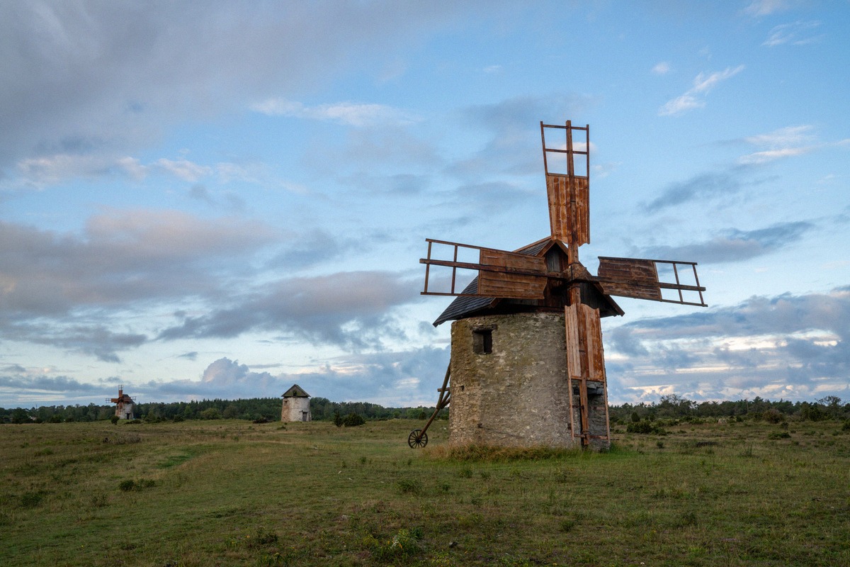
No image defines Öland quite like the windmill. In the 19th century, the island had more windmills turning than almost anywhere else in Europe: at the peak in 1822, there were 1,677 mills. Today, a count by the windmill association, founded in 2008, puts the number still standing at around 350 (351, to be precise).
- The vast majority are post mills (Swedish: stubbkvarnar), the small, rotating wooden mills that dot the open landscape.
- Around 1900 there were roughly 30 larger Dutch-style mills; about ten of these survive today.
- At Lerkaka, five restored windmills stand in a row, a well-known ensemble, more on Lerkaka.
- Sandviks Kvarn, around 30 kilometres north of Borgholm, is one of the largest windmills in northern Europe, with a restaurant and museum on its upper floors.
- Also restored and open to visitors are the mill at Grönhögen and the limestone mill at Jordhamn.
How many of the surviving mills could still actually grind grain isn't documented; what's confirmed is the number of surviving structures. For an overview of routes and history, see the guide Windmills of Öland.
UNESCO World Heritage - Southern Öland
Since 2000, the entire Agricultural Landscape of Southern Öland has been inscribed as UNESCO World Heritage, a common misconception is that only Stora Alvaret is protected. In fact, the World Heritage site covers the whole southern farming landscape, listed under criteria (iv) and (v).
Its centrepiece is Stora Alvaret, a barren limestone plain covering over 260 km² - the largest alvar landscape in Europe. The listing recognises a farming landscape shaped by thin limestone soils and in continuous use for over 5,000 years. More in Stora Alvaret and the overview of Öland's Nature.
Summer home of the Swedish royals
Near Borgholm stands Solliden (Sollidens slott), the Swedish royal family's summer residence since it was completed in 1906, and today the private property of King Carl XVI Gustaf. The residence itself isn't open to visitors - only the palace park, with its gardens and exhibitions, opens from May to September on selected days.
Solliden remains in active use: Crown Princess Victoria celebrates her birthday there every July, most recently on 14 July 2025 with her family, the most recent documented royal visit to the island. The residence's completion in 1906 also gave an extra boost to what was then a young spa and bathing-tourism trade in Borgholm. Practical visiting information is at Solliden Palace.
Kroppkakor, the island dish
Öland's signature dish is kroppkakor, potato dumplings filled with cured pork and onion and served with lingonberries and browned butter. They're traditionally regarded as Öland's national and provincial dish, documented as an "Öland dish" as far back as the mid-18th century. The Öland version uses a mix of raw and cooked potato, which gives the dumplings a greyer colour than the paler Småland version.
Its status as the official provincial dish is actually contested: a 2023 cookbook on Sweden's provincial dishes replaced kroppkakor as Öland's headline dish, which caused a local stir, the dish "lufsa" is often cited as the alternative. Well-known, authentic places to try them include Arontorps Kroppkakor and Ninnis Kroppkaksbod, the only kroppkakor producer listed in the White Guide. For the best places to eat them on the island, see the guide Food & Drink on Öland.
Cycling round the island
The best way to really understand Öland's geography is to ride it: the official main cycle route, the Ölandsleden, circles the whole island for around 450 kilometres in total, from the Långe Jan lighthouse in the south to the Långe Erik lighthouse in the north. It splits into two main sections (around 113 km and 90 km) plus several optional stages.
The route passes 75 nature reserves, an eco-park and the UNESCO World Heritage site. The northern section runs mostly on small, often car-free roads; the southern section shares stretches of busier main roads. There's no official, unified difficulty rating, but the route and flat terrain make the island one of Sweden's most popular cycling destinations. More in the guide Cycling on Öland; for a rundown of the top sights, see Attractions on Öland.